Trends to Track
Crop insurance helps protect your operation from perils caused by mother nature. While there is nothing we can do to prevent damaging weather or weather trends, all growers need to be aware of how they can affect their operation. Meteorologist Lucy Bergemann partners with PRM to break down the most important weather trends for growers in our series “The Trends to Track”. In our first topic, we hear every day about drought, but has it improved? Is it worse? What does the drought look like for our area in the future? Meteorologist Bergemann breaks it down.
Key Takeaways
- Drought is more widespread drought at the start of this calendar year (2023) compared to the start of 2022 but the levels of drought are not as severe
- The winter season has been active in terms of snow & rain, allowing for minor improvements in the drought over the last 3 months
- We are transitioning from a La Nina to an ENSO neutral phase in our atmosphere, the last time this happened was 10 years ago. Parallels can be drawn to the state of the drought in 2013 and 2023.
Recent Precipitation & Impacts
While the last month (late December – late January) has been drier than normal in the Dakotas, the upper Midwest of MN, IA, IL and MO has been “wetter than normal” thanks to atmospheric rivers in California spawning low pressure systems and subsequent snow through the central U.S.. When looking at the last two months, nearly all of the region (ND, SD, IL, MO, MN and IA) is “up” thanks to the winter storm season, seeing above average rain and snowfall. The one exception to this is north of I-70 through the Mississippi River from Missouri into western Illinois.
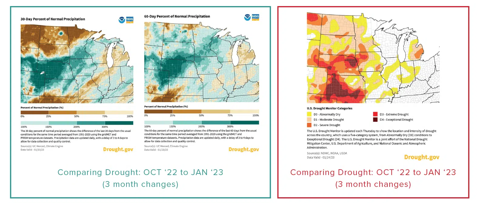
Dakotas & Minnesota
Areas of improvement have been through central South Dakota and central Minnesota with more widespread, albeit minor, drought improvements. There has been no change to the drought coverage in the lower categories of “abnormally dry” and “moderate” through the Dakotas, but there has been a high level of improvement in these states to the level of drought. While South Dakota had coverage of over 30% in severe or higher drought, that percentage is now half. In ND, there was a decrease from ~19% in severe + drought to now 10%.

Missouri & Illinois
Compared to late October there has been a decrease in the amount of drought conditions through the region with IL and MO contributing most significantly to the decrease. In late October, both these states had over 90% of their area in abnormally dry or worse conditions, now it is in the range of 40-60% statewide. The only areas that have gone in the wrong direction for drought conditions were through the areas of Missouri/Illinois mentioned above that have seen below-average rainfall in the past two months.

Iowa
Extreme to exceptional drought conditions are seen through northwest Iowa, stretching in from Nebraska and southeast South Dakota. Despite seeing above normal precipitation this season, we have not noted any changes in the status of extreme drought in western IA & Southeast SD.
Comparing Drought: JAN 22 to JAN 23 (yearly changes)
When we compare this year’s current drought status in late January we can see some notable differences. Last year there was a lower percentage of coverage in drought conditions through the region. This year there is roughly a 15% increase in percent of the area covered by drought conditions, but it is low levels of the drought rather than our most severe levels of drought. Where in 2022 we saw extreme drought conditions through roughly 9% of North Dakota, in Jan 2023, we have 0% coverage. On the flip side of that coin, Iowa has seen an increase of 9% in coverage of extreme drought conditions compared to last year’s 0%.
Soil Moisture
As is typical in the winter season, water in the form of rain, snow, ice and melt, has a much harder time penetrating the frozen ground. Drastic improvements in drought are hard to achieve in the heart of winter. It would be most meaningful then to see the rainfall/snowfall & snowmelt during the late winter and early Spring when temperatures allow the ground to thaw. Seasonally (from late October), there have been improvements to the soil moisture content through the High Plains and Upper Midwest. While still below average in many locations, we have at least seen a trend in the right direction with recent rain and snow amounts factoring into improvements in soil moisture not only on the 1 month scale but also on the 3 month scale.

Future Outlooks: Precipitation and Drought
Outlooks for February from the Climate Prediction Center (CPC), indicate confidence in an above average precipitation month for the Dakotas, Minnesota and through Illinois. Outlooks include average precipitation through Iowa and Missouri meaning drought conditions will persist there without meaningful soaking rainfall or snowfall. The drought outlook issued by the CPC through the next three months (ending in late April 2023) shows confidence in persistent, but not worsening, drought conditions through Nebraska, Kansas and western Iowa. Through the Dakotas and southern Minnesota the CPC anticipates drought removal is likely.

ENSO: El Nino Southern Oscillation & Comparing 2013 to 2023
Part of the contribution to the confidence in drought removal, and at least not worsening, is the La Nina pattern shifting to more of an ENSO Neutral. La Nina is categorized by cooler than average waters in the Eastern Pacific Ocean and tends to lead to colder, more wet patterns through the Pacific Northwest and Central Plains. We have been in La Nina conditions from 2021-2022. The last time we shifted from a period of La Nina into ENSO Neutral was in 2012 (2011/2012 – La Nina) when ENSO Neutral conditions persisted from 2013-2015.
When we look at the January 2013 drought monitor during the transition from La Nina to ENSO neutral, we see *some* similarities between then and now 10 years later. Every category of drought was much more widespread in 2013 compared to 2023, and we had much more intense drought conditions (higher conditions of extreme and exceptional), but the general paintbrush of the map shows a similar coverage area nationwide. The most impacted by drought in both maps are through the Central Plains, stretching into west Texas and the West Coast with lessening drought severity closer to the Midwest.

Bottom Line
We are better off compared to the last time we transitioned from a La Nina to ENSO Neutral phase 10 years ago. We have seen improvements in the past three months by decreasing the highest levels of drought conditions (exception being western Iowa where extreme drought conditions have persisted). While we have not seen major decreases in coverage of drought, we are trending down in the severity of it. With an active winter pattern expected to continue through the winter months with at least above average precipitation through the Dakotas and upper Great Lakes, drought improvement should follow. Unfortunately for those in Iowa and southern South Dakota, the pattern usually “wins” meaning persistent drought through the central High Plains this late winter and early Spring.

Lucy Bergemann is a meteorologist with a passion for explaining and educating on the “whys” of weather. Originally from Boston, MA, Lucy graduated from the State University of New York at Oswego with a B.S. in Meteorology and minors in Communication & Mathematics. Lucy spent 5 years in Colorado, forecasting both on a local and national level. She understands the importance the agricultural industry has on our national and global food security, and how weather is an integral part of the ag culture. Lucy now lives in Southeast Alabama with her husband and is a digital meteorologist for WeatherNationTV, headquartered in Denver, CO.


