In today’s unpredictable agricultural landscape, farmers face mounting risks from weather, market volatility, and input costs. Fortunately, the integration of crop insurance, precision technology, and RTK (Real-Time Kinematic) Boundaries offers a powerful trifecta for managing these uncertainties. By combining the financial safety net of crop insurance with the data-driven insights of precision tech and the pinpoint accuracy of RTK Boundaries, farmers can optimize yields, reduce losses, and make informed decisions, ushering in a new era of resilient, sustainable farming.
RTK Boundary Creation Options
There are different RTK Boundary creation options to look into when deciding to add RTK boundaries as part of the farm’s precision management plan:
RTK Driven Boundaries: Directly measured and recorded using RTK GPS technology using UTV, ATV or Tractor.
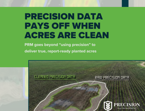
RTK Driven Boundaries are true field edges, including obstacles, ensuring precise
field representation.
RTK Planting Map Boundaries: Derived from RTK Data collected during planting based on where the planter traveled and processed using farm management software.
RTK Planting Map Boundaries may not always align with actual field edges because
of non-passable areas such as prevent plant.
RTK Drone Boundaries: Uses RTK equipped drones to capture field image.
RTK Drone Boundaries cover large areas quickly but require specialized drone equipment and processing software to merge drone photos and draw in the field boundary.
Key Benefits of RTK Boundaries
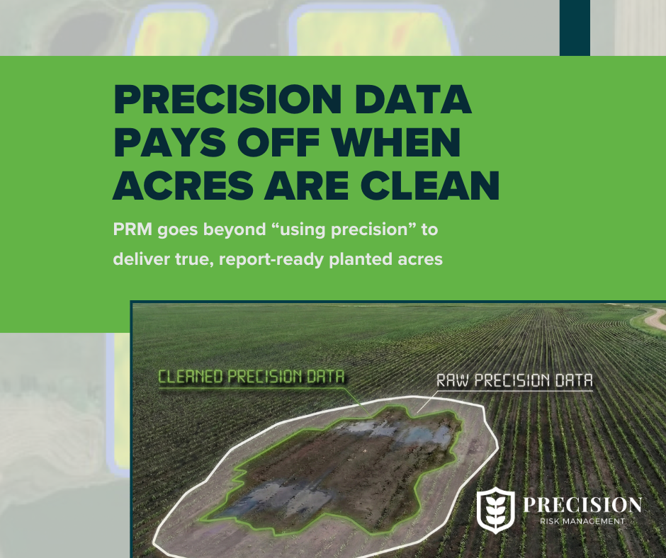
Streamlined Record-Keeping: Farmers can generate precise maps and records, making crop insurance reporting with precision data easier.
Accurate Field Acreage Measurement: Ensure all farm acres are properly accounted for, optimizing land use by making every acre actionable.
Reduced Planting and Spray Overlap: Minimize wasted inputs resulting in reduced cost of seed, fertilizer, chemical.
Reduced Environmental Impact: Accurate application within boundaries reduces risk of run-off in non-target areas protecting investments in conservation efforts
Enhanced Machine Efficiency: Improve efficiency with path planning resulting in reduced labor hours and fuel costs.
Efficient Land Use Planning: Provide accurate spatial data, enabling better field management decisions and data organization making it easier to make data-driven solutions for the future.
Next Steps
Farmers have two options when deciding to implement RTK Boundaries as part of their farm management plan: hire a service provider or drive the boundaries themselves. Each option has advantages depending on the equipment available, time, and needs.
These are some thoughts to assist in deciding which of the two options fit your farm the best when deciding to implement RTK Driven Boundaries:
- Hire Service Provider
Pros:
- Farm Lacks RTK Precision Equipment
- Have Large or Complex Fields
- Not Enough Time or Labor Force
Cons:
- Cost
- Rely on Service Providers’ Schedule
- Changing Boundaries (tree lines, waterways, etc)
2. Driving Boundaries Yourself
Pros:
- Already Have All RTK Equipment
- Need To Update Boundaries Regularly
- Have Smaller or Simple Fields
Cons:
- Time-Consuming
The most cost-effective option depends on farm size, the availability of RTK Equipment, and the frequency of boundary adjustments.
In modern precision agriculture, RTK boundaries deliver sub-inch accuracy, minimizing overlap, boosting efficiency, and cutting costs compared to traditional mapping. Paired with Precision Risk Management’s exclusive Risk and Return Analysis, which leverages your precision data for a field-by-field profitability breakdown, this technology enhances crop insurance and input savings, empowering farmers to maximize profit on every acre.
Contact one of our PRM Advisors to find out more about how RTK Boundaries and Precision Data benefit your crop insurance policy.

